The earliest maps of the Key Peninsula to show geographical features in the uplands and the interior, rather than charting the contour of the coastline, were survey plats created between 1853 and 1857 for the General Land Office. The GLO was the federal agency charged with managing the nation’s public lands, including the territory in the Pacific Northwest that came under the control of the United States with the 1846 Oregon Treaty between the U.S. and Britain. Parts of the land ceded to the U.S. would become the territories and later states of Oregon and Washington.
Survey plats and the field notes of surveyors are important historical documents and have been preserved and digitized by the Bureau of Land Management, the successor agency to the GLO. While primarily intended to take stock of the land and subdivide it into a rectangular grid to facilitate its orderly disposition and settlement, they have also preserved unexpected details that can enrich an understanding of the past and connect the past to the present.
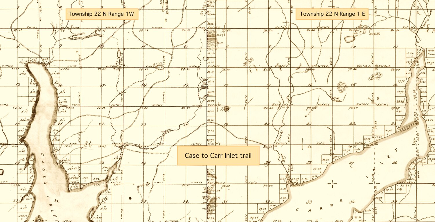
An example of exactly that kind of unexpected detail is found in the surveys and notes for the upper third of the Key Peninsula, the area north of a line roughly between Minter Bay to the east and Rocky Bay in the west. On the survey grid that broad swath of land is identified as township 22 north, ranges 1 east and 1 west of the Willamette Meridian, the north-south axis of the grid. In addition to the Key Peninsula, it includes a portion of Kitsap County as well as parts of Mason County and a large part of the Gig Harbor Peninsula. Range 1 west was surveyed by Isaac Smith and Thomas Berry in November of 1856; Berry returned in May 1857 with William Carlton to survey range 1 east.
A striking feature of the plats includes an unusual maze of double lines, one solid and one broken, that loop around the interior, especially in range 1 west. Those lines are unlike anything seen in the plats for the rest of the peninsula to the south. Some are less than half a mile long, others extend across the entire peninsula. They do not represent topographic contours, which were not shown on the plats, or streams, which are typically depicted with winding lines. The longest such line runs from around Victor in Case Inlet east to near the head of Minter Bay, and looking at it closely reveals its recognizable contour.
The long double line on the 1856 plat roughly matches the route of today’s State Route 302/Elgin-Clifton Road, built by Pierce County in the early 1920s as a shortcut between Gig Harbor and Mason County. The historic community of Elgin, originally Minter, lay at the head of Minter Bay; the town of Clifton in Mason County, platted in 1888, got its present name of Belfair in 1925.
A line that appears to anticipate a road built 70 years later requires an explanation, and the answer is found in the surveyors’ field notes.
Smith and Berry in 1856, and Berry and Carlton in 1857, were following strict instructions. The “Manual of Surveying,” first published in 1850, required them to note, among many other features and data, “roads and trails, with their directions, whence and whither.” They dutifully complied with the instructions, and in so doing they preserved historic evidence of an important cultural resource: the network of historic Native trails across the peninsula that predated the arrival of settlers.
Local archaeologist and anthropologist Lynn Larson said that, even though the Native people on the shores of Puget Sound traveled primarily by sea, they followed and adapted animal trails to send messages and to hunt, pick berries, collect firewood, gather sedge and other plant resources along wetlands for basket making, and cut down trees they would carve into canoes. Several accounts also suggest that canoe portage trails had existed between Carr and Case Inlets, for example between Vaughn and Glen Cove.
In “The Puyallup-Nisqually” (1940), her study of the abandoned cultures of south Puget Sound, anthropologist Marian Smith lists two villages in Case Inlet in the 1800s, home to the Squaxin and located at the head of the inlet near Allyn and Grapeview. On the shores at the north end of Carr Inlet Smith mentions villages at the head of Burley Lagoon, at Minter and in Glen Cove, where the S’Hotlemamish lived.
The Squaxin and the Minter people were connected by strong family ties. Jerry Meeker (1862-1955), whose father was a member of the Puyallup tribe and whose mother was from Minter, remembered that “Squaxin Indians and Minter were more related than anybody ‘round here.” That connection suggests that the trails, particularly the one connecting the head of Case Inlet and Minter, were used regularly and were established enough to be noticed by the surveyors.
In the decades that passed between the years when the surveyors and their teams took the measure of the Key Peninsula and when Elgin-Clifton Road was built, the land was transformed. Arriving settlers logged and farmed it, and an entirely new web of social and economic activity came to define the country. Native villages were slowly abandoned and their people removed in a painful process only now beginning to be understood.
Settlers likely continued to use historic trails until patterns of land use and ownership followed in the early 1900s by the arrival of the automobile made them unusable or obsolete. County surveyors and engineers probably based their alignment of Elgin-Clifton Road and later revised it as much on those cultural factors as they did on terrain and topography. But the plats from the 1850s show that the Squaxin, the people of Minter and those in neighboring villages had been there first, establishing a network of trails in response to cultural needs but also terrain and topography.
In an ironic and poignant twist, evidence of a key part of that culture and its connection to the present day was preserved by surveyors sent by a nation anxious to measure and appropriate their land.


UNDERWRITTEN BY THE FUND FOR NONPROFIT NEWS (NEWSMATCH) AT THE MIAMI FOUNDATION, THE ANGEL GUILD, ADVERTISERS, DONORS AND PEOPLE WHO SUPPORT INDEPENDENT, NONPROFIT LOCAL NEWS