
When Rear Admiral Henry Thomas Mayo (1856-1937) announced his retirement from the U.S. Navy Dec. 10, 1920, after 47 years of service, the news made the papers from his native Burlington, Vermont, to Washington, D.C., and every state in the union. Admiral Mayo’s name was a household word; he had been commander of the U.S. fleet since 1915 and served in World War I. In 1940, three years after Mayo’s death, the destroyer USS Mayo was launched, named in his honor. The ship received two battle stars for her service in World War II and was decommissioned in 1946.
All but forgotten, however, is Henry T. Mayo’s connection to Puget Sound.
In 1880 and ’81, young Ensign Mayo served under Lieutenant Ambrose B. Wyckoff on the schooner Earnest of the U.S. Coast and Geodetic Survey in south Puget Sound, returning for another two years in 1887 and ’88 as a lieutenant. The reconnaissance and survey of the west coast of the United States began in 1850 and would continue for the next several decades, reaching the Sound by 1877. As NOAA’s National Ocean Service defines it, a key mission of the survey is hydrography, or mapping water depth and the shape of the seafloor and coastline, all intended to keep maritime traffic safe.
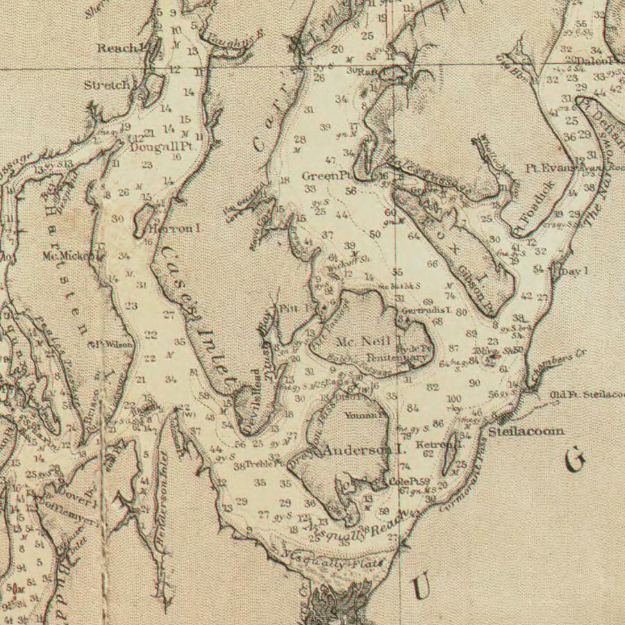
In 1886, the survey published nautical chart 684, entitled “Sea Coast and Interior Harbors of Washington from Grays Harbor to Olympia,” the first detailed survey of Washington’s coast and inland waters. The large chart, measuring 38 inches tall by 32 inches wide, would be reprinted and corrected several times in the decades to follow.
The officers responsible for the survey’s hydrographic work are listed in the chart’s legend; the list includes Ens. H.T. Mayo.
The yet-to-be-named Key Peninsula occupies a small but legible area on the large chart, which extends north of the 49th parallel into British Columbia. Inlets, bays and coves of all sizes are named, among them Mayo Cove, the small bay that according to the 1911 Pacific Coast Pilot, a publication that has guided mariners since 1890, is “locally known as Lake Bay.”
Lake Bay (written as two words) is first attested in 1882 as the name of the post office established on its shores, with settler Henry Tiedeman as its first postmaster. On the first map of Pierce County by surveyor Fred. G. Plummer, published in 1890, the name of the bay is Lake Bay, not Mayo Cove. an early instance of the confusion that continues to this day.
Henry Mayo is not the only member of the survey crew to have his name remembered in that part of Carr Inlet. Wyckoff Shoal, the broad shallow bay between McNeil Island and South Head, spelled Wycoff today, was named after Lt. Ambrose Wyckoff. Like Mayo Cove, the name appears for the first time on the 1886 chart, disproving the claim that it was named in honor of Wyckoff after the lieutenant was appointed commandant of the Puget Sound Naval Station in Port Orchard in 1891.
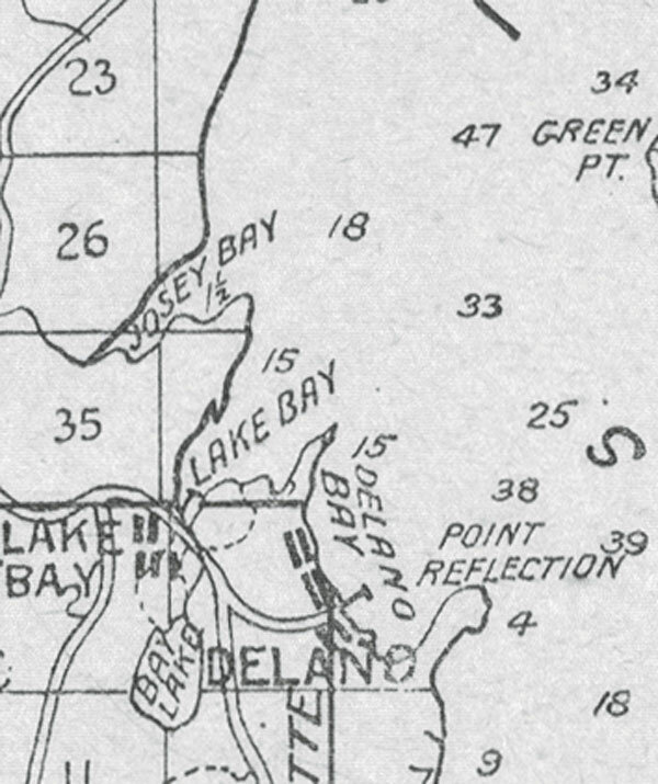
What about nearby Von Geldern Cove, better known as Joe’s Bay since at least 1890 when we find it on the Plummer map spelled as “Josey Bay”?
According to Robert Hitchman in “Place Names of Washington” (1985), Von Geldern was an “early land claimant” on the bay. Land office records, however, do not show anyone by that name ever filing a claim in the area. On the other hand, archival documents do mention a civil engineer named Otto von Geldern (1852-1932) who participated in hydrographic work in south Puget Sound from 1877 to 1881. He would go on to become a prominent member of the Astronomical Society of the Pacific and other scientific bodies in California. Since Von Geldern Cove also appears on the 1886 chart, we can safely conclude that it was named for Otto von Geldern.
A fourth name on the chart associated with the coast survey did not survive. Brown’s Bay, perhaps named after Ens. S.J. Browne who served with H.T. Mayo in 1880-1881, soon became known as Delano Bay after George and Edith Delano, who settled there in 1887 and built their successful resort hotel in 1891.
The coast survey connection may shed light on the origin of the name of McMicken Island in Case Inlet off Harstine Island, which also appears for the first time on the 1886 chart. It has always been thought that the small island was named after William McMicken, the surveyor general for Washington Territory from 1873 to 1886, but no evidence has been found to support the claim. The island appears as Stui Island on the Wilkes atlas published in 1844, but that name did not survive. The survey charts routinely credited the land office, so that may be the missing link. The island may have been named after McMicken in recognition of that relationship.
In his seminal “Origin of Washington Geographical Names” (1923), Edmond S. Meany is silent on the history of Mayo and Von Geldern Coves, Brown’s Bay, Wyckoff Shoal and McMicken Island. Later works on the subject followed suit or offered incorrect or fanciful attributions.
Seven hundred years ago William of Occam argued that the simplest explanation that accounts for a set of facts is to be preferred, a principle known as Occam’s Razor.
Attributing those place names to the scientists and cartographers of the U.S. Coast and Geodetic Survey solves a mystery and neatly accounts for all the facts.


UNDERWRITTEN BY THE FUND FOR NONPROFIT NEWS (NEWSMATCH) AT THE MIAMI FOUNDATION, THE ANGEL GUILD, ADVERTISERS, DONORS AND PEOPLE WHO SUPPORT INDEPENDENT, NONPROFIT LOCAL NEWS