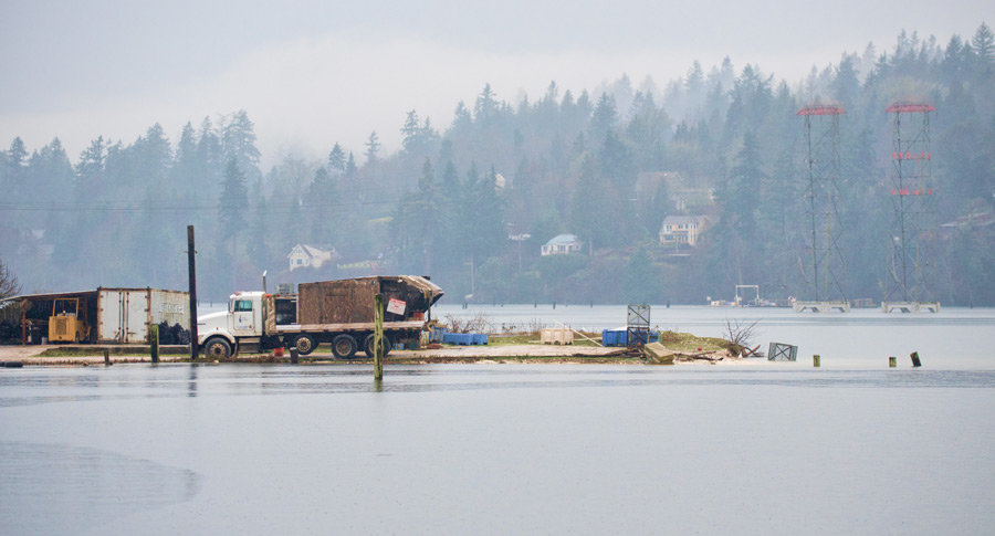
The University of Washington Sea Grant Program has again issued a call for the public to take photographs of the year’s highest tides on Puget Sound and the outer coast. The images sent in by citizen scientists will be added to an ongoing effort to document the effects of high water on local waterfronts.
Sea level has risen slightly but steadily in the last several decades. The rise will accelerate over the next 20 years, according to climate models, though predictions for total rise locally range from a few inches to nearly a foot — and ongoing rise beyond that. King tides offer a window into the future, giving scientists and citizens alike a look at how tidal flooding might affect both natural beaches and manmade structures.
“King tide” is an informal term originating in Australia and the Pacific islands that has spread to North America. The highest tides of the year — the kings — occur in winter for astronomical reasons. The Earth’s perihelion is Jan. 2, when its orbit takes it closest to the sun, creating the largest solar influence on the tides. The moon, which exerts a more powerful sway over the tides, reaches its monthly perigee — its closest point to Earth — Jan. 9.
The new moon arrives Jan. 13, putting the three celestial bodies in a straight sun-moon-Earth line, effectively combining the sun and moon’s gravitational pull on the tides — a situation known as a spring tide, which describes the “springing forth” of water at those times. All of these factors will combine to provide a window into the future.
As with most things in nature, it’s a little more complex than the predictable movement of planets and moons. Weather conditions influence tides, and actual tides can be different from predicted tides by over a foot. Wind determines the size and reach of waves. High atmospheric pressure compresses the water and causes both high and low tides to be lower. The reverse is true of low atmospheric pressure. Puget Sound’s twisting topography amplifies and mutes each tidal movement, as an average of 1.5 cubic miles of seawater works its way into and out of Puget Sound.
King tides continue for several days after the apex of prime celestial conditions because tides “slosh” — an informal term. Puget Sound is a particularly good place to note this tidal sloshing, as tides at the south end of Puget Sound, around Olympia, have a greater range than those around Admiralty Inlet, at the northern entrance.
This complexity makes it all the more important to cast a wide net when documenting the effects of king tides. What happens on one side of the Key Peninsula may not happen on the other side, and models of the future based on a handful of study locations are less powerful than those based on data from everywhere. Citizen-scientist photographs will work to identify flood-prone locations and build understanding of how sea level rise will impact each community.
The most useful photos are those where the tide height can be gauged against landmarks like buildings, roads, sea walls and piers. “MyCoast” is a free phone app available for download on Android or iOS which makes sending photos, complete with location data, nearly as simple as taking the shot. Photos may also be submitted online to mycoast.org/wa.


UNDERWRITTEN BY THE FUND FOR NONPROFIT NEWS (NEWSMATCH) AT THE MIAMI FOUNDATION, THE ANGEL GUILD, ADVERTISERS, DONORS AND PEOPLE WHO SUPPORT INDEPENDENT, NONPROFIT LOCAL NEWS