
The sleek arc of the Purdy Bridge rises in a graceful sweep over the narrow channel between Henderson Bay and Burley Lagoon. An iconic part of the landscape since it was built in 1936, the concrete bridge was placed on the National Register of Historic Places in 1982, one of only eight Pierce County bridges to be included.
A bridge across the channel has been part of the landscape for 130 years, almost five generations, linking the Key Peninsula to the rest of the county but at the same time acting as a physical and notional boundary with it, an instance of the paradox of bridges. It has been loved and hated, used for play or shelter, and crossed by hundreds of thousands over the decades, helping shape the character of the community.
The long history of the current bridge and its predecessors has been mostly forgotten, surviving only in a few recollections and a handful of faded images in archives and private collections. It was a different story over a hundred years ago, back when newspapers from Burley and Gig Harbor to Tacoma reported on its perpetual tussle with the elements, its recurring engineering and maintenance challenges –– but also what in the end was the community’s unflagging will and determination to keep trying until they got it right.
Today’s bridge is not the first span between the sandspit and Purdy.
A succession of three bridges came before, built in 1892, 1905 and 1920-21. All three were supported by timber piles and all three fought valiant but futile battles with the saltwater and fast-moving current.
But those battles and eventual defeats still lay in the future in 1892, when Pierce County commissioners approved the construction of the first bridge across the narrow channel. Until then, people would row or even wade across during low tide. The Tacoma Daily News wrote in September that the new bridge would “enable the farmers of Kitsap and Mason counties to drive to Gig Harbor by a short route and will divert the trade of that section which has hitherto gone to Seattle by way of Sidney (now Port Orchard) to Tacoma by way of Gig Harbor.”
A win for the people of Pierce County and a good use of taxpayers’ money.
The bridge would also undoubtedly benefit businesses and property values in the new town of Springfield, renamed Wauna in 1906 but platted in 1889 on the west side of the lagoon. The road platted through the lower part of town along the bay ended right at the spit; once a bridge was built to Purdy, traffic would be going right through town.
The county’s plan, described in a notice to contractors in September 1892, called for a wooden truss drawbridge with a movable span or draw, measuring 100 feet that would pivot on a center pier. There would also be a fixed span of 70 feet to cover the remaining distance to the approach.
The term drawbridge describes any movable bridge regardless of design.
A swing bridge pivoting around a center pier is the simplest type of drawbridge to build, especially for short spans, although the pier needs to be substantial with a foundation set deep into the ground. A drawbridge was needed to allow marine traffic through, like ships loading lumber at the sawmills in the lagoon or log booms being towed out.
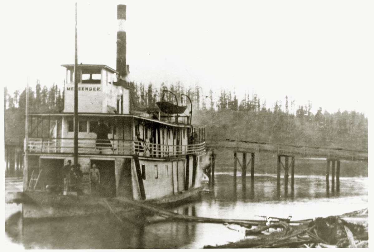
The steamboat Messenger anchored south of the east approach to the first bridge. The Messenger burned in 1894, dating the photo between 1892 and 1894. COURTESY HARBOR HISTORY MUSEUM
Construction began Oct. 15, 1892, and was completed by Christmas at a cost to the county of $4,600, about $150,000 today. At the time it was the only drawbridge in Pierce County outside Tacoma.
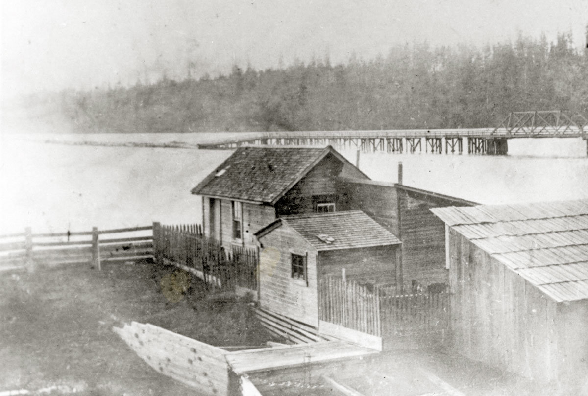
Partial view of the first bridge ca. 1903-1904, showing the west approach and the fixed span. Pearl’s by the Sea restaurant later occupied the site in the foreground, the location today of Massimo Italian Bar & Grill. COURTESY HARBOR HISTORY MUSEUM
But it wasn’t long before the first problems and complaints were reported in the press. At 38 feet wide, the waterway –– the space that steamers had to navigate when the draw was open –– was apparently too narrow for comfort. In March 1896, for example, Captain Thomas Ludlow of the tug Laurel told the Tacoma Daily News that the bridge should be made so “steamers can pass through the draw, which is now so narrow that it gives steamboat men much trouble.”
And then there were the teredos. Known as “termites of the sea,” teredos are wormlike marine bivalves with a long, naked body that bore into wood submerged in saltwater. The piles and piers of the bridge in Henderson Bay were a prime target. An inspection in early October 1896 determined that the 4-year-old structure was already in a “dangerous condition, by reason of the piles being destroyed by teredos,” concluding that 115 piles under the approaches to the bridge had to be replaced.
The bridge is not mentioned in the press again until four years later, in June 1900, this time in an article about the Co-operative Brotherhood, a socialist colony established two years earlier on 260 acres at the head of Burley Lagoon. The colony would only last 15 years but in 1900 it was still young and, according to the article, full of promise and enthusiasm. A shingle mill was doing good business, and there was even talk of buying a steamboat for a better connection to Tacoma.
If only the drawbridge was dependable.
“The bridge at Purdy is in bad condition,” the article said. “It is impossible to open the swing for the passage of boats. The Pierce County commissioners should either put the bridge in shape, or build a new one in a more favorable location and demolish the present structure entirely.”
The Co-operator, the colony’s monthly newspaper, also described the harrowing experience of negotiating passage of a flat-bottomed scow through the narrow waterway in a 1903 article titled “Loading a Scow to Tacoma”:
“It is considered too dangerous by the professional pilots of Tacoma and elsewhere to navigate with their powerful boats, so the Burleyites have to make the passage themselves, under conditions far more nearly impossible. Bravely does the little launch steer its load through the narrow channel, assisted by the men on the scow, who with hands and pikes fend her off the long line of pilings on which the draw swings, and through which the sluice-like tide runs diagonally, endeavoring to use the scow as a big battering machine with which to sweep away the puny works that man has dared to plant in its course.”
In August 1904, the county decided it was time to replace the quickly aging bridge with one of a similar design but a wider draw. This time the draw would pivot on a sturdier concrete-filled center pier. The county engineer’s design had to be approved by the War Department’s Corps of Engineers, since the bridge spanned over waters navigable at half or high tide; a permit was issued in November 1904.
But there was another reason to replace the bridge.
By 1904 a road had finally been built connecting Purdy and Springfield to the communities farther south in today’s Key Peninsula. Settlement from Minter south to Longbranch had accelerated following the completion in 1883 of the Northern Pacific Railroad, connecting the Great Lakes region and the rest of the country to Puget Sound, and the new communities on the peninsula were coming into their own. Steamers of the Mosquito Fleet provided sea transportation, but roads were still needed to link communities to one another and to connect them by land to the growing town of Gig Harbor.
The 1892 bridge across the bay was no longer up to the task. In November of that year the Tacoma Daily News reported that a new bridge was “required on the thoroughfare which gives access to Joe’s Bay, Vaughan, Long Branch and other places in that vicinity.” That thoroughfare would come to be known as the Gig Harbor-Longbranch Road and sections of it would become parts of today’s State Route 302 and the Key Peninsula Highway.
The plans provided for a much more generous draw span of 140 feet, which gave it a clear waterway of 60 feet, an improvement over the earlier 38 feet. The center pier around which the drawbridge would swing was going to be a steel cylinder filled with piles and concrete.
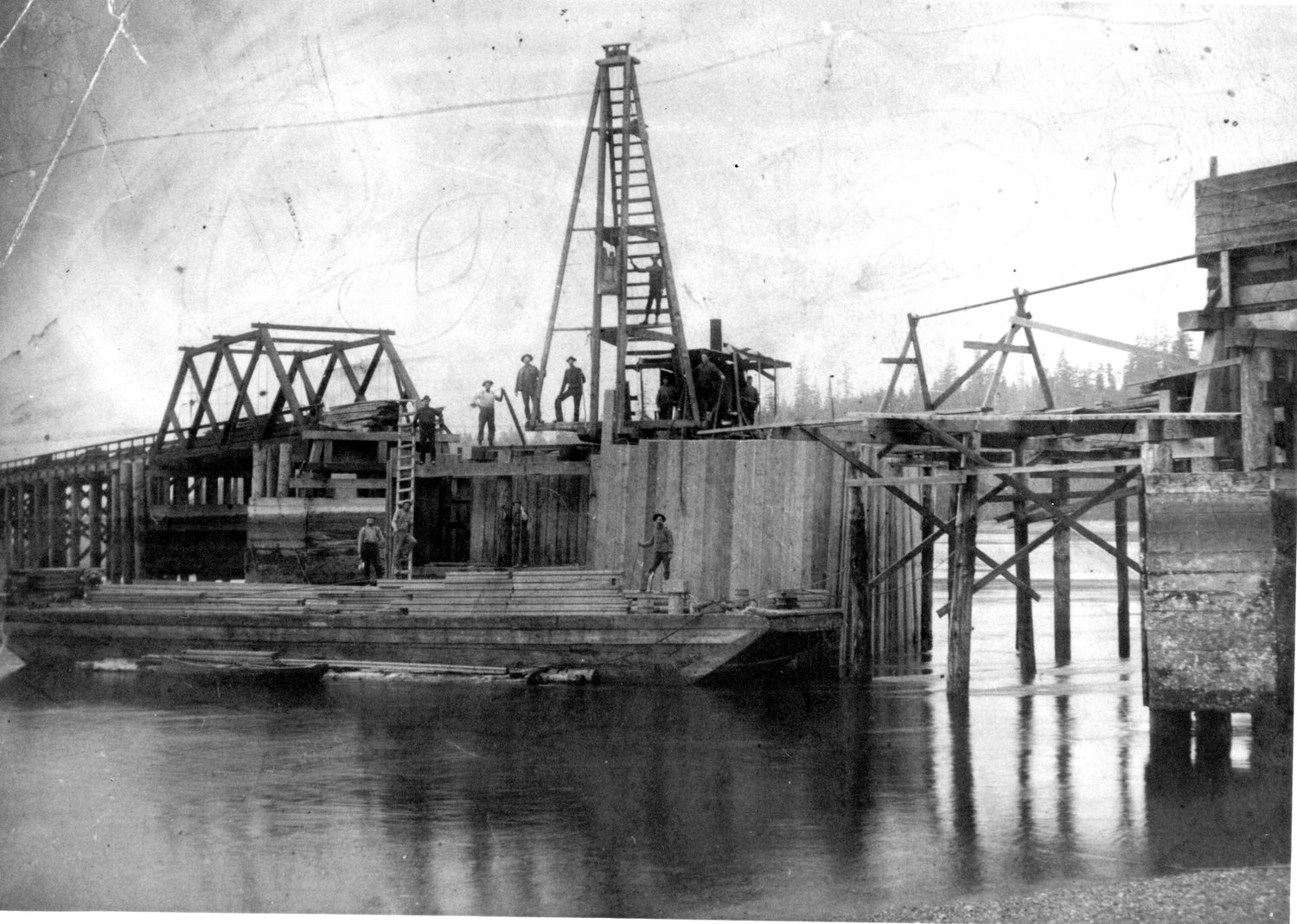
Construction crew takes a break from work on the second bridge to pose for the camera in 1905. COURTESY HARBOR HISTORY MUSEUM
Work started in July of 1905, and the members of Burley colony couldn’t be happier. “A good bridge at Purdy will be much appreciated,” the Co-operator wrote in August, adding that local men were being hired in addition to the contractor’s Tacoma-based crew. “C. M. Anderson, who did such good work on our scow a couple of years ago, is permanently employed,” the paper reported.
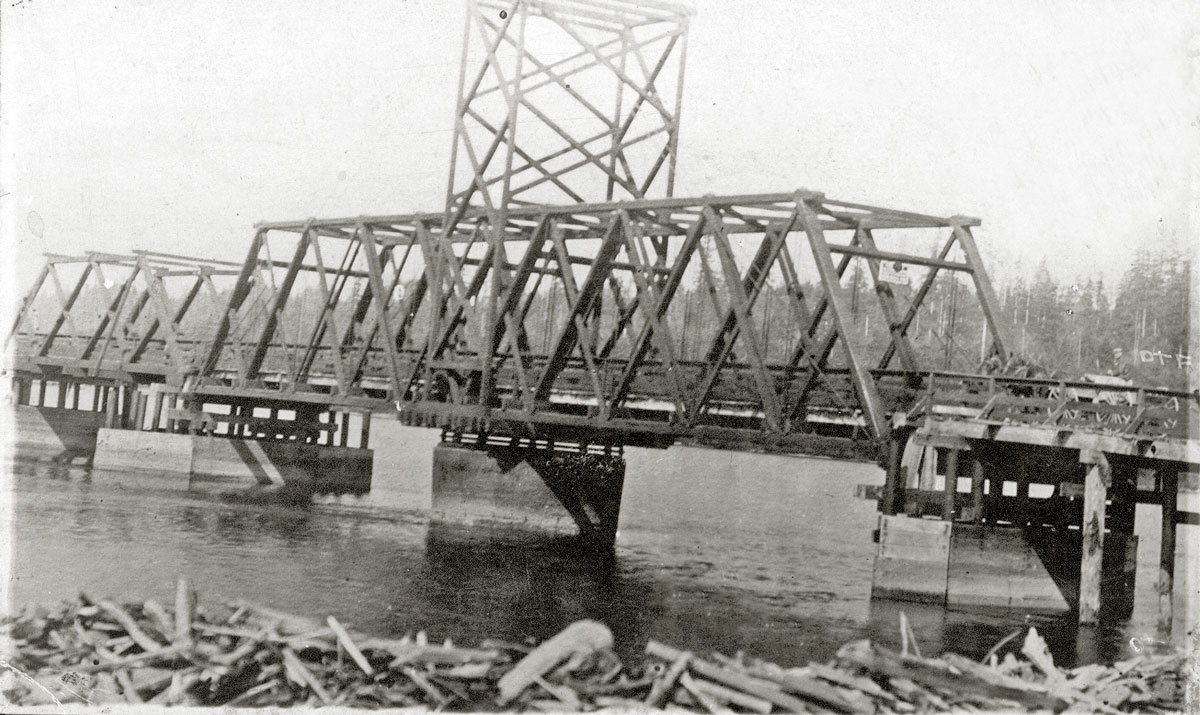
Undated view of the second bridge from Purdy. The swing span turned on the concrete center pier. COURTESY HARBOR HISTORY MUSEUM
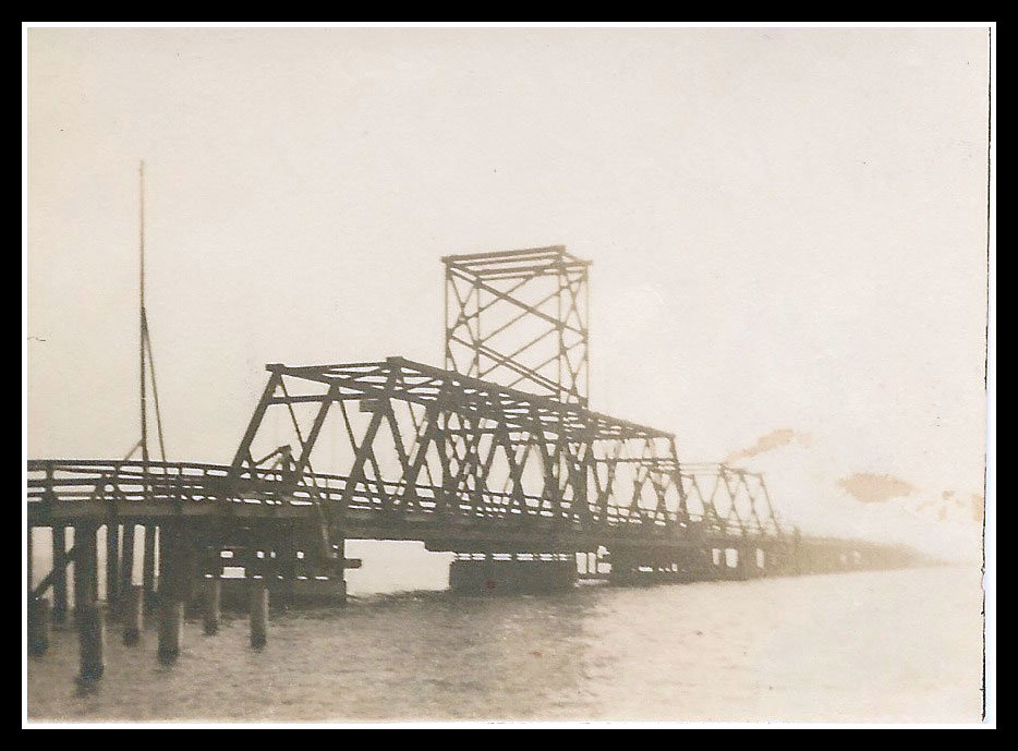
Another undated photo of the second bridge built in 1905, looking southwest from Purdy. The swing span is in the foreground.Laura Knapp Otto Collection
The Co-operator also provided a rare glimpse into the challenge of construction in a marine environment with fast-moving currents.
From September 1905: “The job of building the bridge proves to be difficult, on account of the tide, which, when in, sweeps through the bridge with great velocity, first in one direction and then the other, thus interfering with the handling of their pile-driver and scows, and then again at extreme low tide they are stuck on the bottom and not able to move at all. The iron cylinder, weighing 14 tons, which supports the draw, has been put in place. The inside of this tube has been filled with cement, a small quantity being deposited at a time, making the work progress slowly.”
By December 1905 the new bridge was ready, but apparently all the kinks had not been worked out quite yet.
An article titled “A draw-bridge that won’t draw” on the front page of that month’s Co-operator voiced the colony’s frustration: “A new bridge with a draw resting on the firm foundation of a concrete pier has just replaced the old –– rendered unsafe by age and useless as to navigation by the failure of the drawbridge to swing. Pierce County’s taxpayers are contributing in the neighborhood of $10,000 to pay for the new bridge. But alas! The drawbridge refuses to budge, though five stout arms strain to breaking in the attempt to move it.”
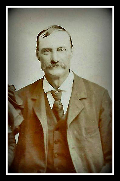
Horace Knapp, ca. 1905. Knapp was appointed bridgetender in 1907.LAURA KNAPP OTTO COLLECTION
The person responsible for operating the bridge was known as a bridgetender. There is no record of an officially appointed bridgetender until 1907. On March 4 of that year a notice in the Tacoma Daily News reported that Horace Knapp held the position. Knapp, 62, had homesteaded on 168 acres on the east side of Henderson Bay. A parcel at the southern tip of the homestead that he had sold in 1897 included the land that would become the east approach to the future bridge.
As bridgetender, Knapp was in charge of operating the draw as needed; he was often helped by his sons, Earl and Seth. It’s likely that Knapp and his teenage sons had already been operating the draw as informal bridgetenders. Earl, who died in 1959, reminisced that the tugs needing to get through would blow one long and two short whistles as they approached Cutts Island about a mile south of the bridge on their way up Henderson Bay. One of the Knapps would then insert a large crank, sometimes referred to as a key, into a slot on the deck of the draw to swing the bridge open and let the boat through.
Other than a few repairs, including the replacement of the center pier which collapsed in 1908, the bridge did not make the news until a little over a decade later, in 1919.


UNDERWRITTEN BY THE FUND FOR NONPROFIT NEWS (NEWSMATCH) AT THE MIAMI FOUNDATION, THE ANGEL GUILD, ADVERTISERS, DONORS AND PEOPLE WHO SUPPORT INDEPENDENT, NONPROFIT LOCAL NEWS